Photo: Wikipedia
Strategic Assessment of Worcester, MA
Multiple tactical vulnerabilities. Population density, target proximity, or disaster risk are likely compounding. A retreat property and exit planning is required.
What does the Strategic Assessment tell us?
Our Strategic Assessment grades tactical survivability of an area. Major population centers, military targets, fallout zones, natural disasters, and border exposure all drive risk — lower exposure means a more defensible position in a crisis.
This is heavily inspired by Joel Skousen's Strategic Relocation book. Highly recommended you checkout the book ($)What does this tell us?
Our Strategic Assessment grades tactical survivability of an area. Major population centers, military targets, fallout zones, natural disasters, and border exposure all drive risk — lower exposure means a more defensible position in a crisis.
This is heavily inspired by Joel Skousen's Strategic Relocation book. Highly recommended you checkout the book ($)Strategic Pillars

Key Distances
Regional Safe Places
Below is our recommended "safe zones" in Massachusetts and the surrounding area based on our strategic heuristics. For most people, it's unrealistic to live in a “safe zone” full-time due to work, family or other personal reasons. They tend to be more rural. However, many of these areas are perfect for second homes and retreat properties that double as a vacation home or even a short-term rental.


Important Note: For informational purposes only. This does not mean nothing bad ever happens in the green zones. Please use common sense. This is based on public data and modeled with AI. We tried to take a conservative approach but mistakes happen. We update this regularly as new information becomes available.
Solar Generator Recommendations
Backup power matters more here than in safer locations. We've picked three solar generators across budgets and capacity tiers — start with the budget unit if you only need a few essentials, or step up if you want to run a fridge and HVAC for days at a time.

Jackery Portable Power Station Explorer 300
Budget OptionPower on the Go: Weighing only 11 lbs, it's convenient to set up and store with book-sized foldable solar panels

BLUETTI Portable Power Station AC180
Designed for both indoor and outdoor scenarios, AC180 is highly capable as it has a robost capacity and continuous output power.

EF ECOFLOW DELTA Pro Ultra Power Station
Upgraded PickEcoFlow DELTA Pro Ultra is a whole-home energy system designed to grow with your family. Integrated with the Smart Home Panel 2, it scales to meet your evolving energy needs — keeping your home powered, intelligent, and secure through every stage of life.
We earn a commission, at no additional cost to you.
Strategic Assessment Analysis
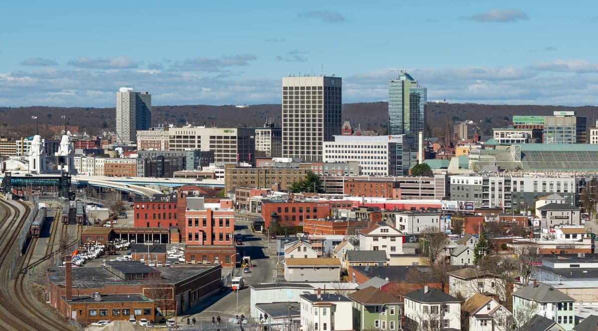
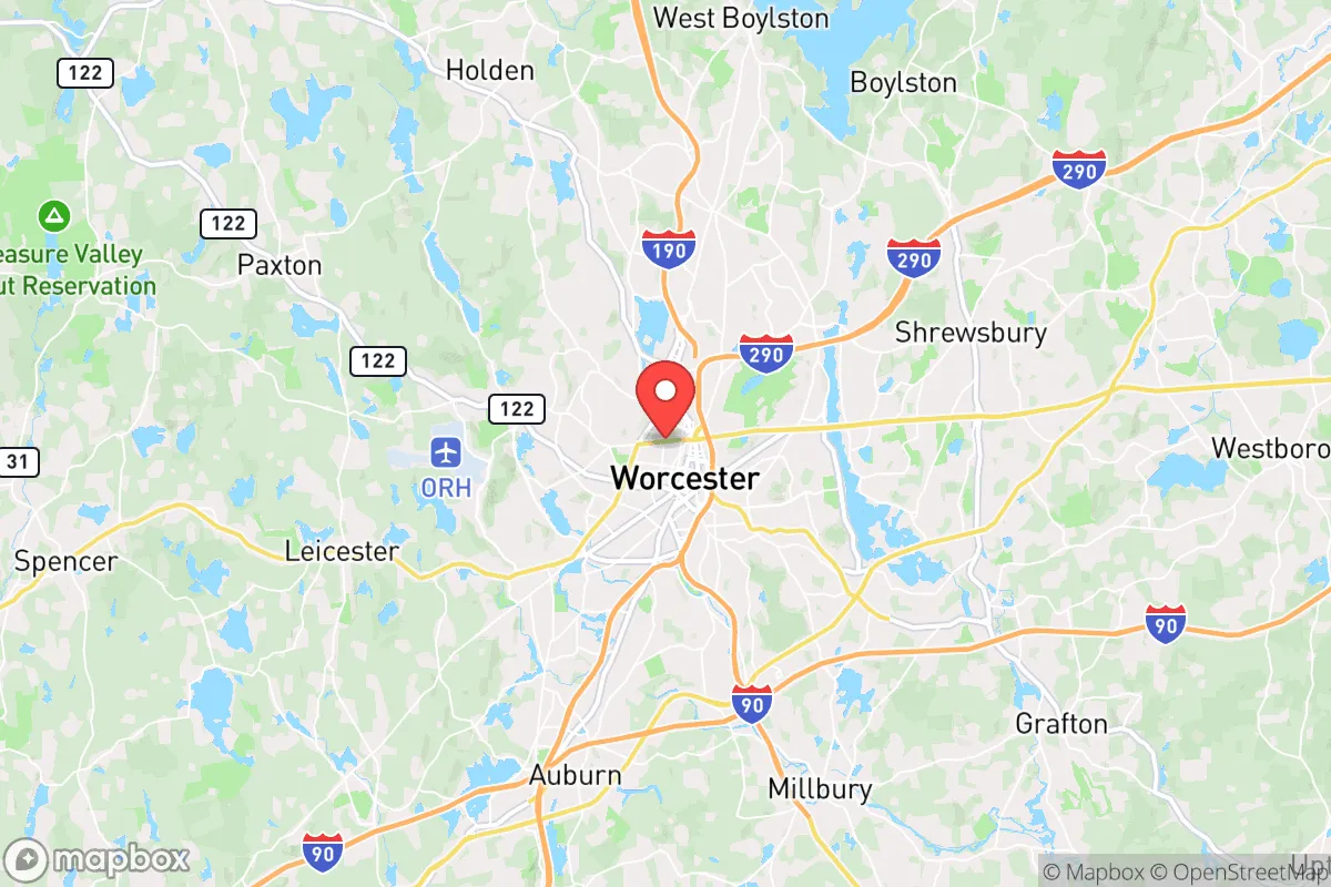
Worcester, Massachusetts, often called the "Heart of the Commonwealth," presents a complex strategic picture for the conservative prepper or survivalist. Its central location in New England offers genuine logistical advantages—sitting at the crossroads of I-90, I-290, and I-495, roughly 40 miles west of Boston and 40 miles east of Springfield—but those same highways make it a potential chokepoint and target during civil unrest. The city’s population of over 205,000, combined with its dense urban core and aging infrastructure, creates a high-risk profile for anyone prioritizing long-term self-sufficiency and security. For the relocator thinking in terms of TEOTWAWKI scenarios, Worcester is less a sanctuary and more a strategic staging ground—one that demands a clear-eyed assessment of its vulnerabilities before committing to the area.
Geographic position and natural advantages for long-term survival
Worcester sits on a plateau in central Massachusetts, which gives it a modest elevation advantage—roughly 480 feet above sea level—over the coastal flood zones of Boston and Providence. This elevation reduces the risk of storm surge from hurricanes or sea-level rise, a genuine concern for East Coast preppers. The surrounding landscape is a mix of second-growth forest, small farms, and the Blackstone River Valley, which provides a natural water source and potential for off-grid agriculture. The city is within a 30-minute drive of the Quabbin Reservoir, one of the largest man-made water supplies in the Northeast, holding over 400 billion gallons. For a relocator, this means a viable water source exists nearby, though access during a crisis would likely be contested. The region’s four-season climate—cold winters with heavy snow, humid summers—is a double-edged sword: it provides natural barriers to movement during winter months but also demands serious cold-weather preparedness. The area’s rocky, hilly terrain offers some defensible positions, particularly in the western suburbs like Holden or Paxton, but the city itself is a bowl, making it a natural collection point for refugees fleeing coastal chaos.
Risks, exposures, and proximity to fallout-relevant landmarks
Worcester’s proximity to high-value targets is its most glaring weakness. Boston, home to Logan International Airport, the Port of Boston, and the Federal Reserve Bank, is a likely primary target for any large-scale attack or civil disruption. Worcester lies directly along the primary evacuation corridor (I-90) from Boston, meaning any mass exodus from the coast will funnel people straight through the city. The city itself hosts several infrastructure nodes that could become secondary targets or points of failure: Worcester Regional Airport (a small but active facility), the CSX rail yard, and the UMass Memorial Medical Center—the largest hospital in central Massachusetts. Additionally, the city is within 50 miles of the Pilgrim Nuclear Power Station (decommissioned but still storing spent fuel) and the Seabrook Station nuclear plant in New Hampshire, both of which pose fallout risks in a catastrophic event. The city’s dense urban layout, with narrow streets and aging buildings, creates a nightmare scenario for evacuation or sheltering during a chemical or radiological incident. For the survivalist, Worcester’s location is a liability: it’s close enough to Boston to be affected by its collapse, but not far enough to offer a buffer.
Practical resilience for a relocator: food, water, energy, and defensibility
For the individual or family looking to set up a resilient household in the Worcester area, the practical challenges are significant. The city’s water supply comes from the Worcester Water Filtration Plant, drawing from the Holden and Lynde reservoirs, which are surface sources vulnerable to contamination or sabotage. A prepper would need a backup plan—well water is rare within city limits, but properties in the outer suburbs (e.g., Leicester, Auburn) often have private wells. Food security is weak: Worcester has a handful of farmers’ markets and community gardens, but the city is a food desert in the sense that most grocery stores are chain operations (Stop & Shop, Price Chopper) that would empty within hours of a crisis. The city’s energy grid is part of the ISO New England system, which has faced strain during winter storms and heatwaves; natural gas lines run through the city, and a major pipeline rupture could cut heating for thousands. Defensibility is poor in the urban core—dense row houses, limited sightlines, and multiple entry points make a neighborhood watch or perimeter defense nearly impossible. However, the surrounding hill towns—Princeton, Rutland, Sterling—offer far better defensibility with rural road networks, stone walls, and forest cover. For a relocator, the smart play is to live in one of these towns and use Worcester as a resource hub for supplies, medical care, and information, not as a primary residence.
The overall strategic picture for Worcester is one of calculated risk. It’s not a survivalist’s paradise—the city’s density, proximity to Boston, and infrastructure vulnerabilities make it a poor choice for a bug-in location during a major crisis. But for the relocator who understands the terrain, it offers a unique advantage: access to the resources of a mid-sized city while being within striking distance of some of the most resilient rural land in New England. The key is to treat Worcester as a staging area, not a sanctuary. Stockpile supplies in a secure rural property within a 20-minute drive, learn the back roads that bypass the main highways, and build a network with like-minded locals in the hill towns. The city’s hospitals, hardware stores, and fuel depots will be critical in the first 72 hours of any event, but after that, the smart money moves to the high ground. For the conservative prepper willing to put in the work, Worcester can be a viable base of operations—but only if you’re prepared to leave it behind when the lights go out.
* Values derived from national, state, county, city and local statistics and may differ in a specific area. Last updated: 2026-05-01T21:34:17.000Z
Narrative content on this page is AI-generated and may contain mistakes. Verify any details that matter before acting on them.
ReloMaps may earn a commission from affiliate links at no extra cost to you.