
Photo: Wikipedia
Strategic Assessment of Monterey County
Meaningful friction. Expect exposure to either population pressure, blast zones, or natural disaster risk. Consider buying a retreat property.
What does the Strategic Assessment tell us?
Our Strategic Assessment grades tactical survivability of an area. Major population centers, military targets, fallout zones, natural disasters, and border exposure all drive risk — lower exposure means a more defensible position in a crisis.
This is heavily inspired by Joel Skousen's Strategic Relocation book. Highly recommended you checkout the book ($)What does this tell us?
Our Strategic Assessment grades tactical survivability of an area. Major population centers, military targets, fallout zones, natural disasters, and border exposure all drive risk — lower exposure means a more defensible position in a crisis.
This is heavily inspired by Joel Skousen's Strategic Relocation book. Highly recommended you checkout the book ($)Strategic Pillars

Key Distances
Strategic Assessment Analysis
Monterey County presents a contradictory picture for the strategic relocator. On one hand, the region boasts productive agricultural land, remote coastal terrain, and a military presence in Fort Hunter Liggett that could serve as a stabilizing force during unrest. On the other hand, its location within California places it downstream of major population centers, critical infrastructure, and natural disaster risks that demand careful calculation. For a conservative-minded individual or family preparing for civic disruption or mass casualty events, this county offers real advantages but only if you are willing to navigate its liabilities with eyes open.
Why geographic position and natural features matter for preparedness in Monterey County
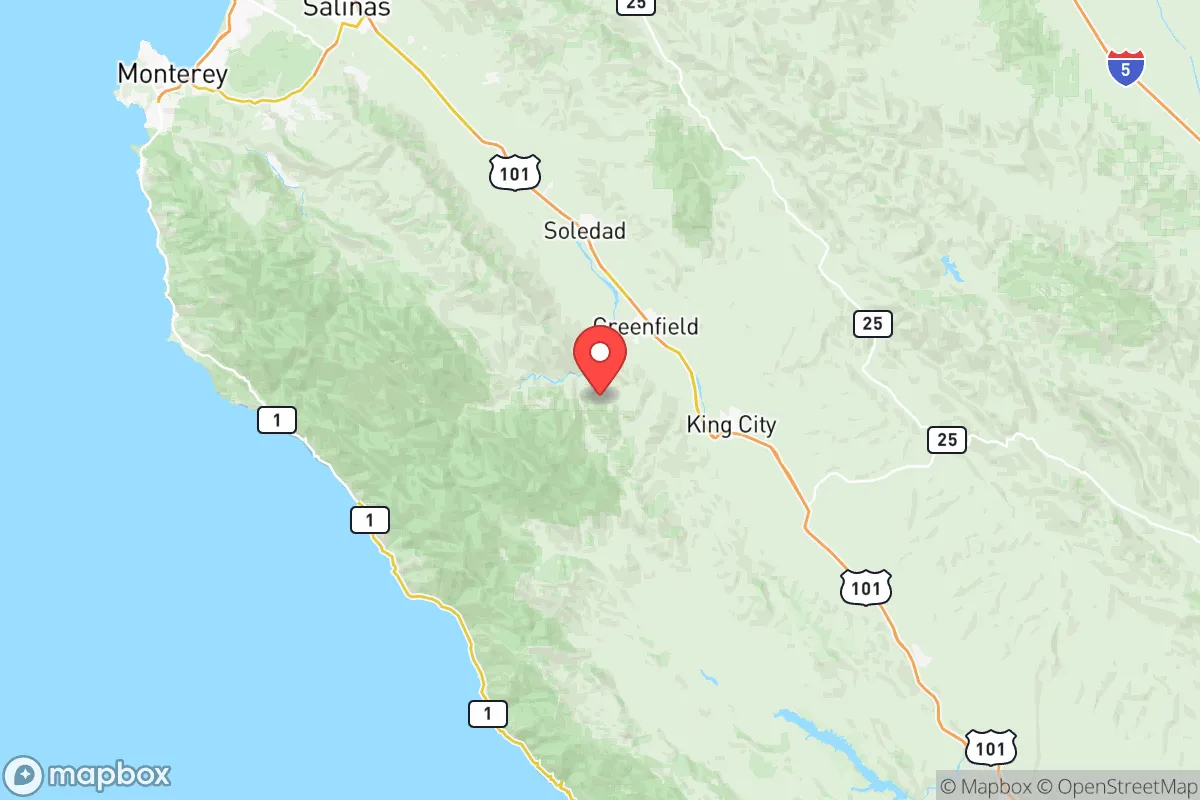
From a survival geography standpoint, Monterey County gives you a split personality. The coastline from Monterey south to Big Sur offers rugged, defensible terrain with limited access points — Highway 1 can be cut or monitored at several choke points. The inland Salinas Valley, running from Salinas south past King City, provides flat agricultural bottomland with abundant water access from the Salinas River and its tributaries. The county also hosts Pinnacles National Park on its eastern edge, offering remote public land with caves, rock formations, and limited road access that could serve as a fallback zone. The real strategic asset, however, is Fort Hunter Liggett in the southern portion of the county. This active Army training base spans over 160,000 acres of remote grassland and oak savanna. In a breakdown scenario, proximity to a military installation with a permanent security footprint and potential for command-and-control continuity is a factor most relocators overlook. The base sits far from the coastal population centers, buffered by the Los Padres National Forest to the west and agricultural land to the north. That kind of institutional anchor matters when assessing regional stability.
Critical risks, exposure zones, and proximity to fallout-relevant landmarks
Now for the hard truths. Monterey County sits within range of several high-value targets that could generate secondary fallout — both literal and figurative. The Moss Landing Power Plant, a massive natural gas facility on the coast just north of Monterey, is the largest power plant in the state and a clear infrastructure target. A strike or major failure there would black out the entire central coast and could release hazardous materials depending on the event type. Further north, the greater San Francisco Bay Area is a primary target zone for any state-level adversary, and Monterey County lies within the fallout plume corridor for ground bursts in the Bay or Santa Clara Valley, depending on prevailing westerly winds. The county is also home to California State Prison, Soledad, a maximum-security facility holding several thousand inmates directly adjacent to Highway 101. During a mass unrest scenario, this prison represents a liability for any nearby relocator — escape events, staff absenteeism, and potential for the facility to become a target for outside actors. Add to this the fact that the county sits on the San Andreas Fault near Parkfield and the Hayward Fault system. Earthquakes are not a hypothetical here; they are an inevitability that could trigger cascading failures in the very infrastructure you depend on. Wildfire risk is equally serious, especially in the Big Sur corridor and the coastal ranges, where single-road access can become a death trap during fire season. For the relocator prioritizing security, the county's position between the populated Bay Area corridor and the remote central coast means you are exposed to threats from both directions.
Practical resilience for relocators: food, water, energy, and defensible ground
This is where Monterey County earns its keep for the prepared individual. The Salinas Valley is consistently ranked as one of the most productive agricultural regions in the United States, producing lettuce, strawberries, broccoli, wine grapes, and dozens of other crops year-round. For a relocator looking to secure local food sources independent of long supply chains, this matters enormously. Farmers markets, direct-to-consumer farm stands, and relationships with local growers can be established before any crisis hits. The water picture is more complicated — the Salinas Valley groundwater basin has known overdraft issues and seawater intrusion along the coastal interface. Surface water from the Salinas River and county reservoirs like Nacimiento and San Antonio provides supplementary supply, but these are subject to drought allocation and regulatory battles. Energy resilience is weak for the typical homeowner. The grid is heavily dependent on Moss Landing and long transmission lines from PG&E, both vulnerable to earthquake damage and intentional disruption. Solar with battery storage should be considered mandatory here, not optional. Defensible property exists in the county's inland and southern zones. The area around King City and San Ardo offers larger parcels, lower population density, and terrain that provides natural standoff. A well-chosen property with good road access — and an alternative back way out — gives you breathing room that coastal parcels simply cannot provide. That said, the county's regulatory environment is still California. Permit processes, water rights, and building codes are not friendly to off-grid independence. You have to work within the system here, not around it.
The overall strategic picture for Monterey County requires honest assessment. For the relocator who values food security, remote terrain, and the stabilizing presence of a major military installation, this county offers foundations that few coastal regions in California can match. But those advantages come with exposure to earthquake risk, wildfire corridors, proximity to high-value infrastructure targets, and the inherent instability of the state's political and regulatory apparatus. If you are looking for a place that balances productive land with military proximity and defensible geography — and you are willing to accept the seismic and regulatory trade-offs — Monterey County deserves a deliberate look. It is not a bug-out location. It is a long-term strategic position that requires preparation, not a retreat.
* Values derived from national, state, county, city and local statistics and may differ in a specific area. Last updated: 2026-06-01T14:04:16.000Z
Narrative content on this page is AI-generated and may contain mistakes. Verify any details that matter before acting on them.
ReloMaps may earn a commission from affiliate links at no extra cost to you.