
Photo: Wikipedia
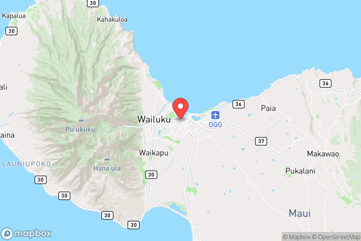
Strategic Assessment of Kahului, HI
Strong survivability profile. Good buffer from population centers, with manageable environmental and tactical risks.
What does the Strategic Assessment tell us?
Our Strategic Assessment grades tactical survivability of an area. Major population centers, military targets, fallout zones, natural disasters, and border exposure all drive risk — lower exposure means a more defensible position in a crisis.
This is heavily inspired by Joel Skousen's Strategic Relocation book. Highly recommended you checkout the book ($)What does this tell us?
Our Strategic Assessment grades tactical survivability of an area. Major population centers, military targets, fallout zones, natural disasters, and border exposure all drive risk — lower exposure means a more defensible position in a crisis.
This is heavily inspired by Joel Skousen's Strategic Relocation book. Highly recommended you checkout the book ($)Strategic Pillars

Key Distances
Regional Safe Places
Below is our recommended "safe zones" in Hawaii and the surrounding area based on our strategic heuristics. For most people, it's unrealistic to live in a “safe zone” full-time due to work, family or other personal reasons. They tend to be more rural. However, many of these areas are perfect for second homes and retreat properties that double as a vacation home or even a short-term rental.


Important Note: For informational purposes only. This does not mean nothing bad ever happens in the green zones. Please use common sense. This is based on public data and modeled with AI. We tried to take a conservative approach but mistakes happen. We update this regularly as new information becomes available.
Solar Generator Recommendations
Backup power matters more here than in safer locations. We've picked three solar generators across budgets and capacity tiers — start with the budget unit if you only need a few essentials, or step up if you want to run a fridge and HVAC for days at a time.

Jackery Portable Power Station Explorer 300
Budget OptionPower on the Go: Weighing only 11 lbs, it's convenient to set up and store with book-sized foldable solar panels

BLUETTI Portable Power Station AC180
Designed for both indoor and outdoor scenarios, AC180 is highly capable as it has a robost capacity and continuous output power.

EF ECOFLOW DELTA Pro Ultra Power Station
Upgraded PickEcoFlow DELTA Pro Ultra is a whole-home energy system designed to grow with your family. Integrated with the Smart Home Panel 2, it scales to meet your evolving energy needs — keeping your home powered, intelligent, and secure through every stage of life.
We earn a commission, at no additional cost to you.
Strategic Assessment Analysis
Kahului, as the commercial and transportation hub of Maui, presents a paradox for the strategic relocator. Its central location on the island’s isthmus offers unmatched logistical convenience, but that same centrality makes it a chokepoint in any crisis scenario. For the conservative prepper, Kahului is less a final redoubt and more a critical waypoint—a place to stage resources, maintain supply lines, and monitor the pulse of the island before moving to a more defensible position inland or upcountry.
Geographic position and natural advantages for long-term survival
Kahului sits on the flat, dry isthmus between the West Maui Mountains and Haleakalā, giving it a unique dual-access advantage. The area is sheltered from the dominant trade winds by the West Maui Mountains, which reduces storm exposure compared to windward coasts like Hāna. The Kahului Harbor is the island’s primary deep-draft port, handling over 90% of Maui’s imported goods—fuel, food, building materials, and medical supplies. In a grid-down scenario, this harbor becomes the single most valuable piece of infrastructure on the island. The Kahului Airport (OGG) is the second-busiest in the state and serves as a potential evacuation or resupply hub, though it would also be a target for looting or government seizure during civil unrest. The natural advantages here are clear: flat terrain for agriculture, consistent rainfall in the nearby upcountry slopes, and a central position that allows rapid movement to any quadrant of the island. However, the isthmus is also a wind tunnel during Kona storms, and the low elevation offers zero concealment from aerial surveillance or satellite observation.
Risks, exposures, and proximity to fallout-relevant landmarks
Kahului’s greatest vulnerability is its role as Maui’s primary target. The harbor, airport, and major fuel storage tanks at Kahului Harbor are all high-value assets in any conflict scenario—whether foreign or domestic. The area is also directly in the path of tsunami waves generated by earthquakes along the Aleutian Trench or local submarine slides; the 1946 and 1960 tsunamis both caused significant damage here, with run-up heights exceeding 20 feet in some areas. For the prepper, the proximity to the harbor means that any maritime incident—a ship collision, a chemical spill, or a deliberate attack—could render the entire area uninhabitable for weeks. Additionally, Kahului is less than 10 miles from the Kahoolawe target range, a former Navy bombing range that still contains unexploded ordnance and residual contamination. While not an active fallout source, it serves as a reminder that the military considers this region a live-fire zone. The nearby Kihei and Wailea resort corridors, with their dense tourist populations, would become chaotic refugee zones during a collapse, funneling desperate people north into Kahului. The area’s flat, open terrain offers no natural defensive positions—no ridges, no forests, no caves. A determined group could be observed and interdicted from miles away.
Practical resilience for a relocator: food, water, energy, and defensibility
Kahului’s practical resilience is a mixed bag. The municipal water supply comes from the Iao Aquifer, which is generally reliable but vulnerable to saltwater intrusion during drought or over-pumping. A well-drilled prepper could tap into the shallow groundwater on the isthmus, but the water table is brackish in many spots, requiring reverse osmosis or distillation. The area’s agricultural history is strong—sugar cane and pineapple once dominated—but those fields are now mostly fallow or developed. Small-scale farming is possible, but the dry climate means irrigation is mandatory. The Maui County Farm Bureau and local co-ops offer some support, but the soil is thin and volcanic, requiring amendment. For energy, Kahului has grid-tied solar with net metering, but the grid itself is fragile; the 2023 Lahaina fires exposed the utility’s inability to manage vegetation and infrastructure. A standalone solar-plus-battery system is essential, and propane backup for refrigeration and cooking is wise. Defensibility is the weak point. Kahului is a grid of flat streets with no natural chokepoints. The best defensive strategy is to not be in Kahului when trouble comes—use it as a supply depot and transit hub, then relocate to a more defensible property in Kula, Makawao, or even Hāna. The local police presence is minimal relative to population, and the Maui Police Department’s response times in a crisis would be measured in hours, not minutes. The community is diverse but not particularly cohesive; the prepper will find few like-minded neighbors and should keep a low profile.
The overall strategic picture for Kahului is one of calculated risk. It is not a survivalist’s paradise—it is a logistics node. For the conservative relocator who understands that mobility and supply are more important than static defense, Kahului offers the best access to fuel, food, and medical evacuation on the island. But the area’s exposure to tsunami, its status as a primary target, and its lack of defensible terrain mean that it should never be a permanent bug-in location. The smart play is to establish a base here for resupply and intelligence gathering, while maintaining a secondary, hidden property upcountry or on the remote east side. In a world of cascading failures, Kahului is the place to watch the storm from the window—not the place to ride it out.
* Values derived from national, state, county, city and local statistics and may differ in a specific area. Last updated: 2026-04-24T00:06:39.000Z
Narrative content on this page is AI-generated and may contain mistakes. Verify any details that matter before acting on them.
ReloMaps may earn a commission from affiliate links at no extra cost to you.