
Photo: Wikipedia
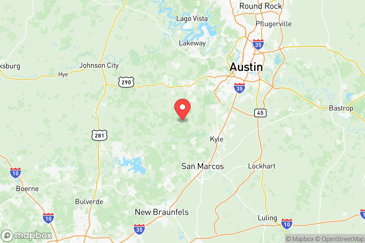
Strategic Assessment of Hays County
Meaningful friction. Expect exposure to either population pressure, blast zones, or natural disaster risk. Consider buying a retreat property.
What does the Strategic Assessment tell us?
Our Strategic Assessment grades tactical survivability of an area. Major population centers, military targets, fallout zones, natural disasters, and border exposure all drive risk — lower exposure means a more defensible position in a crisis.
This is heavily inspired by Joel Skousen's Strategic Relocation book. Highly recommended you checkout the book ($)What does this tell us?
Our Strategic Assessment grades tactical survivability of an area. Major population centers, military targets, fallout zones, natural disasters, and border exposure all drive risk — lower exposure means a more defensible position in a crisis.
This is heavily inspired by Joel Skousen's Strategic Relocation book. Highly recommended you checkout the book ($)Strategic Pillars

Key Distances
Strategic Assessment Analysis
Hays County, Texas, occupies a strategic sweet spot in the state’s rapidly growing I-35 corridor, offering a blend of rural buffer and suburban infrastructure that appeals to those prioritizing resilience. Its position between the liberal strongholds of Austin to the north and San Antonio to the south provides a geographic cushion—close enough to access major medical and supply networks, yet far enough to avoid the immediate chaos of urban collapse. For a conservative-leaning relocator, the county’s explosive growth (population surged from 157,000 in 2010 to over 280,000 by 2025) signals both opportunity and a need for careful site selection, as the eastern edge near I-35 is increasingly dense while the western Hill Country remains sparsely populated and defensible.
Geographic position and natural advantages for long-term security
Hays County’s topography is its first line of defense. The western half, anchored by the towns of Wimberley and Dripping Springs, sits atop the Balcones Escarpment, offering elevated terrain with natural chokepoints along the Blanco River and Cypress Creek. This high ground provides clear lines of sight and limits approach vectors for any potential threat—whether civil unrest or natural disaster. The county’s position roughly 30 miles from both Austin and San Antonio means it’s outside the likely blast radius of any major urban target, yet within a two-hour drive of Fort Cavazos (formerly Fort Hood) to the north, a major military installation that could serve as a stabilization point during federal emergencies. The Edwards Aquifer recharge zone runs through the eastern part of the county, ensuring reliable groundwater access for those with private wells, while the Hill Country’s limestone bedrock offers excellent basement and bunker construction potential—a rarity in Texas.
Risks, exposures, and proximity to fallout-relevant landmarks
No strategic assessment is complete without acknowledging the liabilities. Hays County’s eastern flank, particularly the city of San Marcos and the I-35 corridor, is a double-edged sword. San Marcos is home to Texas State University (over 38,000 students), which in a crisis could become a focal point for civil unrest, resource competition, or mass evacuation gridlock. The county’s proximity to Austin-Bergstrom International Airport (about 25 miles from downtown San Marcos) and the Lockheed Martin facility in South Austin places it within a secondary fallout zone if those sites were targeted. More concerning is the Houston Ship Channel and its refinery corridor—roughly 160 miles southeast—which, if struck, could send toxic plumes across the coastal plain, though Hays County’s elevation and prevailing winds from the south-southeast offer partial mitigation. The South Texas Nuclear Generating Station near Bay City is about 180 miles away; while not an immediate fallout risk, prevailing weather patterns could carry contamination inland during a worst-case scenario. Flooding is the primary natural hazard—the Blanco River flooded catastrophically in 2015 (killing 13 in Wimberley)—so any property purchase must account for FEMA flood zones and drainage patterns.
Practical resilience for a relocator: food, water, energy, and defensibility
For a family or individual serious about self-sufficiency, Hays County offers a workable foundation with caveats. Water is the strongest asset: the Trinity and Edwards aquifers provide deep, reliable groundwater, and properties in western Hays County (around Driftwood and Kyle) can often drill wells yielding 10-20 gallons per minute at 200-400 feet. Rainwater catchment is also viable, with annual rainfall averaging 34 inches. Food production is feasible but not effortless—the limestone soil requires raised beds or imported topsoil for vegetable gardens, though native pecan and live oak trees provide mast crops, and deer hunting is abundant (Hays County is in the Edwards Plateau ecological region with healthy whitetail populations). Energy independence is achievable: solar irradiance averages 5.2 kWh/m²/day, and many rural properties have no HOA restrictions on panels or battery storage. However, the county’s connection to the ERCOT grid is a vulnerability—Winter Storm Uri in 2021 left parts of Hays County without power for up to 72 hours, and the grid remains under strain. A backup generator or off-grid solar setup is non-negotiable. Defensibility varies by location: the western Hill Country offers natural barriers (steep ravines, dense cedar breaks) and low population density (under 50 people per square mile in some precincts), while the eastern suburbs near Buda and Kyle are increasingly suburbanized with typical subdivision layouts that are harder to secure. The county’s law enforcement presence is solid—the Hays County Sheriff’s Office maintains a visible patrol presence, and the San Marcos Police Department is well-funded—but during a widespread emergency, response times in rural areas could exceed 30 minutes.
The overall strategic picture for Hays County is one of calculated trade-offs. It offers genuine advantages in water access, elevation, and proximity to military infrastructure, but the I-35 corridor’s growth and the county’s position between two major liberal cities create a tension that a relocator must resolve through property selection. The western Hill Country—specifically areas around Wimberley, Dripping Springs, and the unincorporated stretches of Hays County Precinct 3—provides the best balance of defensibility, resource access, and distance from urban fallout zones. The eastern suburbs are increasingly compromised by density, traffic, and reliance on centralized infrastructure. For a conservative-leaning individual or family willing to invest in well-drilling, solar, and food storage, Hays County can serve as a viable long-term base. But it is not a retreat—it is a forward operating position, requiring active preparation and a clear-eyed understanding that the buffer zones are shrinking every year as development pushes westward from I-35.
* Values derived from national, state, county, city and local statistics and may differ in a specific area. Last updated: 2026-05-12T11:22:14.000Z
Narrative content on this page is AI-generated and may contain mistakes. Verify any details that matter before acting on them.
ReloMaps may earn a commission from affiliate links at no extra cost to you.